First mentioned in 1341 its Swedish community had lived according to the 17th century manners when they left on August 4 in 1944. The 1644 built church is one of the oldest wooden buildings in Estonia. Small island but one of the deepest boreholes in Estonia is there too--787.4 meters and of very salty curative water. The 19th century lighthouse is French.
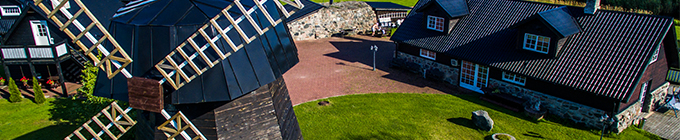
In 1925, as many as 9 windmills were standing on the top of Windmill Mountain. Five of them, having survived until today, also give a powerful impression. Four out of the five Angla windmills are typical trestle windmills, characteristic of Island Saare...
Although a steady ship connection between Saaremaa and the main land was set already in the 17th century and the ice bridge helped out in winter the connection still depended on the weather. Having been built from the both ends the dam was finished in 1...


)

)
)

)
)
)